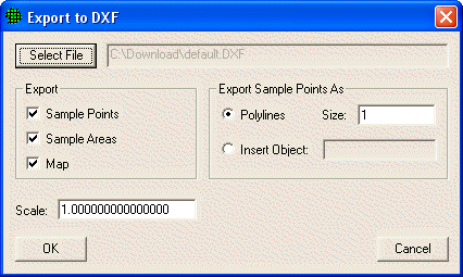
This command exports the graphical element of the current sample plan to a Drawing Interchange Format (DXF) file used by CAD systems.

The dialog contains these features:
Select File button |
allows you to select the DXF file to be written |
Export Sample Points checkbox |
checking this will write the Sample locations into the DXF file. |
Export Sample Areas checkbox |
checking this will write the Sample Area outlines into the DXF file. |
Export Map checkbox |
checking this will write the Map lines into the DXF file. |
Export Sample Points As radio button |
If you choose to write Sample Points into the DXF file, they will be written either as Polylines with a set shape or as Insert objects.
|
Scale |
If you want to change the size of your current project map, enter a number other than 1. Entering a 2 would take your current map and put it at twice its size into the DXF map file. |