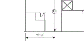
This command allows you to scale the current map so that map distances match the distances represented in a background picture. To use it, you need to know the distance between two points on the background picture; a reference scale in the background image is ideal for this purpose.

After selecting this command, select two points on the background picture for which the desired distance is known. This command presents a dialog that allows you to match locations on the map with points on the picture. (If a Picture World File is available for the background picture, use it instead of this process.) At this time, there is no way to adjust the angle of the picture or the angle of the coordinate system within Visual Sample Plan. Therefore, the picture must be exactly aligned with north at the top and south at the bottom.
The picture calibration is a two-point process. It requires you to match two different map locations to points on the picture. When selecting points, the Control key can be pressed to have the line snap to the horizontal or vertical direction.
After the points are selected, a dialog appears with the current distance the map shows between the two points. Enter the correct distance between the two points. The map will be scaled accordingly.
To check the result, you can re-select the option, select the same two points again and examine the new distance between them.