This command imports UXO reconnaissance data from a text file. Most tools used for transect sampling in VSP involve georeferenced geophysical data collection. The recon data options, on the other hand, support reconnaissance surveys usually conducted by walking over a site and completing a visual inspection and magnetometer readings rather than a detailed geolocated and geophysical measurement along the transects. Recon data typically records anomalies as counts between distantly-spaced points on a path. The point location along with the number and types of objects observed between the points in collected and stored in a row/column format. Each row contains information about a specific segment.
Once imported, the Find UXO Targets design and the Map Geostat Anomaly Density Design can be configured to use this reconnaissance data rather than the typical geophysical data used in VSP.
Recon data is contained in a tab-delimited text file. The file should have a single heading line. It works best if the heading follow the standard heading names specified here, otherwise the proper columns will need to be specified by the user. There is an example recon file included with VSP if you want to see the process in action. To do so, select this command from the menu and then choose Recon-Example.txt. which is installed in your "My Documents" \ Visual Sample Plan folder.
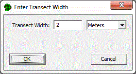
After you specify the file to import, VSP asks for the transect width. This is the width of observation by the person conducting the survey - typically 1 to 2 meters. If loading the Recon-Example.txt, enter 2 meters.
Next VSP tries to locate key data columns in the specified file:
Data Type |
Non-Case Sensitive Column Heading Names |
X Coordinate |
"x" or "point_x" |
Y Coordinate |
"y" or "point_y" |
Point Type |
"pnt_typ" |
Surface Item Count (may be multiple columns) |
Any or all: "surf_hits", "uxo", "dmm", "md", "rrd", "cd" |
If any of the first three columns (X Coordinate, Y Coordinate, Point Type) is not found, VSP presents a dialog requesting the user to specify the column for each of the data:
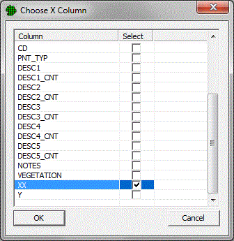
If the user does not specify the column, the import is cancelled.
VSP also checks for the presence of the "sub_hits" (sub-surface hits) column. If not found it asks the user to select it. If the user does not specify the column, however, the import is not cancelled.
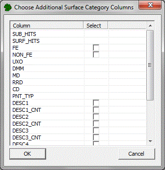
Next, VSP asks the user to specify any other column(s) to be included in the surface item counts:
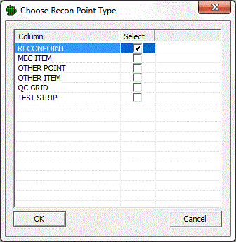
Next, VSP searches the "Point Type" column to find the "Recon Point" type. If it is not found, it asks the user to select which label indicates a "Recon Point".
Next, VSP searches the "Point Type" column and finds any entry that is not a "Recon Point" and puts them into a list and then asks the user to select which points types to load:
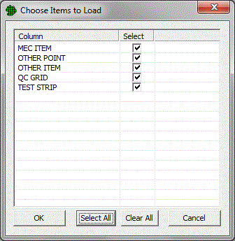
These other (non-Recon) point types that are loaded are displayed on the map, but not used in other analysis.
Finally, if all the data fall outside of defined sample areas, VSP asks if you want to create a sample area to contain them. If you choose No, the import will be aborted. If you choose Yes, VSP may also ask you to specify the units to use for the map.
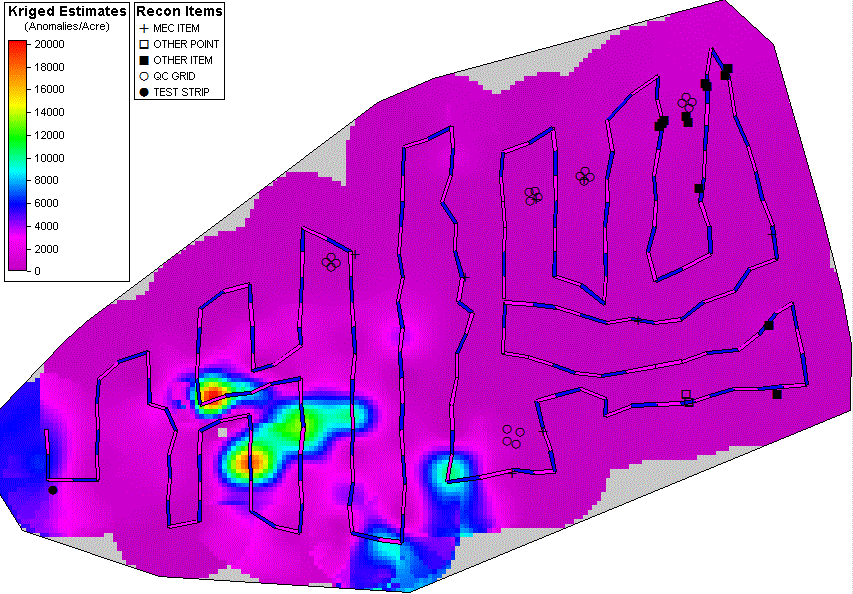
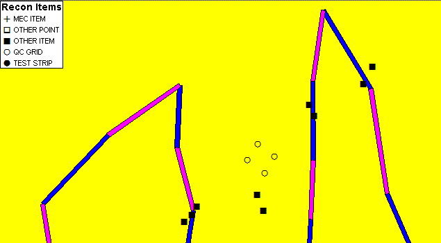
As the data is loaded for each line, if it is a "Recon Point" (as indicated by the "Point Type" column), then it is stored as a transect on the map (see the magenta and blue sections):
The counts of the "surf_hits", "uxo", "dmm", "md", "rrd", "cd" (as well as any other surface count columns specified by the user) are stored in the transect segment (defined as the line from the previous "Recon Point" to the current "Recon Point"). Once loaded, the recon data is available for analysis in the Find UXO Targets Design or the Map Geostat Anomaly Density Design. When used in analysis, the counts are spread evenly across the length of the transect segment.
If the recon data line is one of the items to load (as specified by the user from the "Point Type" column) it is loaded as a recon display point. Each different recon display point type is assigned a different symbol for display on the map. Right-click on the Recon Items legend to change the symbols, or to select which item types to show or hide.
When recon data is present on the map, the Find UXO Targets Design and Map Geostat Anomaly Density Design contain a section that allows you to use the recon data instead of default geophysical data:
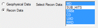
You can select any or all of the surface data types to analyze. (If none are selected, the analysis will fail.) If you want to do the Map Geostat Anomaly Density Design after importing the Recon-Example.txt file, you will also need to select the "Scale Intermediate Values" option. Here are the geostat anomaly mapping results from the Recon-Example.txt file using all of the surface (non sub_hits) recon data types: