In some cases, it is possible to conduct a Geophysical survey that covers an entire DoD site or facility to map the density of anomalous metallic readings in order to search for Target Areas at which munitions were fired or dropped. This is opposed to the usual case where only a small portion of the site is surveyed by geophysical detectors at widely spaced linear intervals, referred to as transects.
The mapping of anomaly densities provides a continuous estimate of the density of metallic anomalies for the entire study site. This spatially continuous representation is important for the detection of high density areas and for providing a basis for other spatial analyses. The basic output from this process is a map showing an estimate of how the metallic anomaly density varies across the study site. The only input to the process (other than the site map) is a list of all anomaly location coordinates. The anomaly locations can be imported on the data page .
After anomaly locations are imported into VSP, there are two parameters that are needed to create the density map: grid size and smoothing level.
The grid size defaults to 1% of the longer of the site length or width. This default grid size can be changed by the user. The site is divided into square grid cells as the basis of the density map. The raw density of each grid cell is simply the number of anomalies inside the grid cell divided by the size of the grid cell.
Smoothing is used to minimize drastic density differences between adjacent grid cells. The smoothing level can be set to minimum, medium or maximum. The default smoothing level is medium, until changed by the user. The method of smoothing is described below.
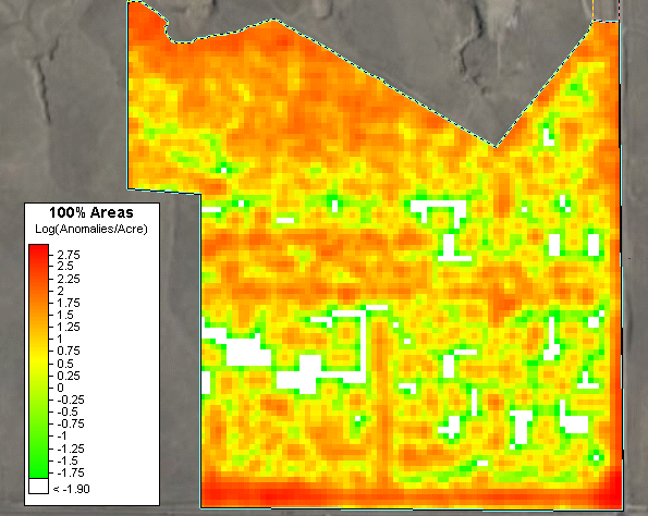
Clicking on the Apply or Okay button from the 100% Areas dialog page will initiate the process of dividing each sample area into grid cells, computing the density for each grid cell, smoothing the density values and displaying the density map. The anomaly density map is displayed in VSP as a color-shaded value map (Figure 1). The default color scheme has the highest density values shown in red and the lowest values shown in green. A color scale is provided to aid in interpretation of the results.
Figure 1- Results of density mapping displayed in VSP
The color scheme used for the anomaly density display can be changed by right-clicking on the color scale displayed on the map and changing the Color Set parameter on the Legend Properties dialog. Various color palettes are available. Selecting one with a larger color range will bring out more details in the anomaly density estimate. You can also choose to display the logarithms of the density values in order to bring out details of highly skewed density distributions. This is accomplished by checking the Log Scale box on the Legend Properties dialog. If the color scale is not visible on the map, check the 100% Area Density Legend under View Settings on the Layer Control .
Smoothing is accomplished by replacing the density of each grid cell by a weighted average density of itself and nearby grid cells. The amount of smoothing (minimum, medium or maximum) determines how many grid cells are used for the average and how much each cell contributes to that average. The smoothed density for each current grid cell is computed as: $$D_{\text{smooth}} = \frac{\text{SW/SG}}{\text{AA}}$$
Where: $$\text{SW} = \displaystyle\sum_{r=-s}^{s}\displaystyle\sum_{c=-s}^{s} D_{r, c}*G_{r, c}*A_{r, c}$$
$$\text{SG} = \displaystyle\sum_{r=-s}^{s}\displaystyle\sum_{c=-s}^{s} G_{r, c}$$
$$\text{AA} = \frac{SA}{n}$$
$$\text{SA} = \displaystyle\sum_{r=-s}^{s}\displaystyle\sum_{c=-s}^{s} A_{r, c}$$
and
\(r\) is the row offset from current cell
\(c\) is the column offset from current cell
\(D_{r, c}\) is the raw density value of the cell r rows and c columns relative to the current cell
\(G_{r, c}\) is the Gaussian weight (see tables below)
\(A_{r, c}\) is the area of the cell r rows and c columns relative to the current cell. Most cells are the same size, however some cells may be truncated at the edge of the sample area.
\(s\) is the relative index range. For minimum smoothing the indices are -1, 0, 1. For medium smoothing the indices are -2, -1, 0, 1, 2. For maximum smoothing the indices are -3, -2, -1, 0, 1, 2, 3. At the edges of the sample area, these indices will be truncated as necessary.
\(n\) is the number of cells used for the average density. For minimum, medium and maximum smoothing \(n\) is normally 9, 25 and 49 respectively. However, at the edges of the sample area \(n\) will be reduced as necessary.
G,r,c |
c |
|||
-1 |
0 |
+1 |
||
r |
+1 |
0.019491 |
0.121440 |
0.019491 |
0 |
0.121440 |
0.756655 |
0.121440 |
|
-1 |
0.019491 |
0.121440 |
0.019491 |
G,r,c |
c |
|||||
-2 |
-1 |
0 |
+1 |
+2 |
||
r |
+2 |
0.000602 |
0.007657 |
0.017632 |
0.007657 |
0.000602 |
+1 |
0.007657 |
0.097313 |
0.224099 |
0.097313 |
0.007657 |
|
0 |
0.017632 |
0.224099 |
0.516073 |
0.224099 |
0.017632 |
|
-1 |
0.007657 |
0.097313 |
0.224099 |
0.097313 |
0.007657 |
|
-2 |
0.000602 |
0.007657 |
0.017632 |
0.007657 |
0.000602 |
G,r,c |
c |
|||||||
-3 |
-2 |
-1 |
0 |
+1 |
+2 |
+3 |
||
r |
+3 |
0.000093 |
0.000946 |
0.003773 |
0.005977 |
0.003773 |
0.000946 |
0.000093 |
+2 |
0.000946 |
0.009590 |
0.038254 |
0.060598 |
0.038254 |
0.009590 |
0.000946 |
|
+1 |
0.003773 |
0.038254 |
0.152597 |
0.241730 |
0.152597 |
0.038254 |
0.003773 |
|
0 |
0.005977 |
0.060598 |
0.241730 |
0.382925 |
0.241730 |
0.060598 |
0.005977 |
|
+1 |
0.003773 |
0.038254 |
0.152597 |
0.241730 |
0.152597 |
0.038254 |
0.003773 |
|
+2 |
0.000946 |
0.009590 |
0.038254 |
0.060598 |
0.038254 |
0.009590 |
0.000946 |
|
+3 |
0.000093 |
0.000946 |
0.003773 |
0.005977 |
0.003773 |
0.000946 |
0.000093 |
On this page, you can enter the anomaly data. The course-over-ground and 100% grid areas section will be disabled for this design.
On this page, you can view histograms or box-and-whisker plots of the mapped density data.
Delineate High Density Areas page
This page can be used to draw reproducible boundaries around high density anomaly regions given user specifications.